The Microsoft Location Finder is a great tool for finding your exact location on a map. It is compatible with computer displays and uses an active Internet connection, including Wi-Fi, to update your GPS readings. The visualization options are helpful for getting a better sense of your location, and the latest location feeds from devices are useful for tracking movement. Overall, the Microsoft Location Finder is a great tool for quickly finding your exact location.
Microsoft Location Finder 3.0 is a handy tool, which using the current location of the computer, generates orientation maps, distances and optimal routes between two cities, and 3D visual tours.
The program generates this information using Wi-Fi signals detected within the area near the PC. However this PC does not need Wi-Fi, but any type of Internet connection. It runs on Windows 2000 and Windows XP.
Once you install the software on your computer, you'll see an icon in the lower right rectangle on your screen. From there, you can activate the Locate Me function and start generating maps. In addition, you can configure it to start automatically when you start Windows.
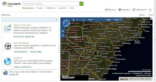
Generating Maps
By default, it’ll generate a 2D map of the area of location of your PC, which you can move and change of scale through the expansion and reduction tool. You can also show or hide information labels.
You’ll be able to choose between two types of 2D views for the maps: road view and aerial view, both with the same functions.
3D View
With this feature you’ll be able to generate a 3D visualization of the map with Virtual Earth 3D (Beta). Using the functions of Virtual Earth 3D you’ll be able to take virtual tours with various 3D photos of the area being displayed. Also, you’ll be able to configure various general visualization and 3D mode options, such as change of image frequency, reproduction quality of these, and the inclusion of icons and titles.
Directions
Through this feature you’ll be able to obtain the optimal route, in distance or time, between two cities you choose. The program will show you the journey on the map and will list several intermediate points, with their distances and partial times.
Finally you’ll be able to send the map to others you want to share it with, or print it directly from your PC.


Comments (4)
Not a good one.